Samstein1012 - AD ASTRA PER ASPERA
More Posts from Samstein1012 and Others
RIP

While flying over Boston, Leonard Nimoy’s birthplace, NASA Astronaut Terry Virts pays tribute to the Star Trek star http://nbcnews.to/1AUElvf

InSight Mission to Mars

Our InSight mission will place a fixed science outpost on Mars to study its deep interior. Findings and research from this project will address one of the most fundamental questions we have about planetary and solar system science – How in the world did these rocky planets form?
By investigating the interior structure and processes of Mars, the InSight mission will gain a better understanding of the evolutionary formation of planets, including Earth.
InSight will record Mars’ vital signs to learn more about the planet, including:

Seismic Activity:
A seismometer will be used to record the seismic activity on Mars. This will give us information on the crust, mantel and core; and the relationship between them.

Temperature:
A heat flow probe will be used to take Mars’ temperature and determine the change over the course of a full Martian year.

Reflexes:
By looking at how the rotation of Mars wobbles, we will better understand what the core size may be and its composition.

Launch for the InSight mission is scheduled for March 2016, and even though you can’t physically travel with the lander, you can send your name to the Red Planet onboard. Make sure to submit your name before Sept. 8!
Make sure to follow us on Tumblr for your regular dose of space: http://nasa.tumblr.com
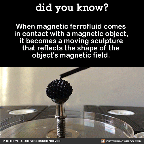
When magnetic ferrofluid comes in contact with a magnetic object, it becomes a moving sculpture that reflects the shape of the object’s magnetic field. Source
The NASA “Worm” Logo
Just like many organizations, the style and logos can change over time. You are probably most familiar with our “meatball” logo. No, unfortunately this does not refer to the delicious food. This logo (below) is our most popular symbol, and dates back to 1959.
But, we’ve also had other insignia that represented our organization throughout the years.
The “worm” logo (below) was used by the agency from 1975 until 1992. The organization wanted to create a more “modern” logo, which resulted in the unique type style of the “worm” logo.

Even though this logo was retired in 1992, the Graphics Standards Manual is still available online HERE.
You can also read up about the emblems, logos and insignia used by NASA throughout the years in a new e-Book available for free HERE.
Make sure to follow us on Tumblr for your regular dose of space:http://nasa.tumblr.com
6 Ways Earth Observations Tackle Real-World Problems
This summer, 30 research projects were launched by recent college graduates and early career professionals as part of our DEVELOP program. The aim is to use our satellite observations of Earth to address an environmental or public policy issue. And they have just 10 weeks to do it! On Aug. 10, 2016, the “DEVELOPers” gathered at our Headquarters in Washington, DC to showcase their results. So, how can Earth observations solve real-world problems? Let’s take a look:

1. They help land managers identify the locations of invasive species.
Austin Haney, DEVELOP project co-lead at University of Georgia, has seen first-hand how an invasive species can affect the ecosystem of Lake Thurmond, a large reservoir that straddles the border between Georgia and South Carolina. Birds in the area “behave visibly different,” he said, after they consume a toxic cyanobacteria that lives on Hydrilla verticillata, an invasive aquatic plant. Ingesting the toxin causes a neurodegenerative disease and ultimately death. Scores of birds have been found dead near lake areas where large amounts of the toxin-supporting Hydrilla grow. To help lake managers better address the situation, Haney and project members developed a tool that uses data from the Landsat 8 satellite to map the distribution of Hydrilla across the lake.
Image Credit: NASA/Bill Ingalls

2. They help identify wildlife habitat threatened by wildfires.
Maps that depict habitat and fire risk in eastern Idaho previously stopped short of Craters of the Moon National Monument and Preserve, where shrubs and grasses transition to a sea of ankle-twisting basalt. But the environment is not as inhospitable as it first appears. Throughout the monument there are more than 500 kipukas —pockets of older lava capable of supporting some vegetation. That means it is also prone to burning. Project lead Courtney Ohr explained how her team used data from the Landsat 8 and Sentinel-2 satellites to develop a model that can simulate the area’s susceptibility to wildfires. Decision makers can use this model to monitor the remote wildlife habitat from afar.
Image Credit: NASA/Bill Ingalls

3. In conjunction with Instagram, they help find seaweed blooms
Who knew that Instagram could be a tool for science? One DEVELOP team searched for photographs of massive seaweed (sargassum) blooms in the Caribbean, mapped the locations, and then checked what satellites could see. In the process, they tested two techniques for finding algae and floating vegetation in the ocean.
Image Credit: Caribbean Oceans Team

4. They help conserve water by reducing urban stormwater runoff.
Atlanta’s sewer system is among the nation’s most expensive. Yet, the city still struggles with stormwater. It’s an uphill climb as new construction paves over more of the city, hindering its ability to absorb rain. The University of Georgia DEVELOP team partnered with The Nature Conservancy to address the problem.
Using satellite imagery, the team was able to pinpoint areas well-poised to capture more of the city’s runoff. They identified 17 communities ripe for expanding green infrastructure and reforestation. The team used the Land-Use Conflict Identification Strategy and Soil and Water Assessment Tool models and Landsat and Terra satellite data. Their analysis provides local groups with a working picture of the city’s water resources.
Image Credit: NASA/Bill Ingalls

5. They show the spread of the mite eating away Puerto Rico’s palm trees.
The red palm mite has devastated Puerto Rico’s trees in recent years. The insect chewed its way through coconut palms, bananas, and plantains on the island in the recent decade. Its spread has hurt crops across the Caribbean.
A DEVELOP team led by Sara Lubkin analyzed satellite imagery to track the mites’ rapid spread from 2002. The team mapped changes to vegetation, such as yellowing, and differences in canopy structure. They made use of imagery from Landsat, Hyperion, IKONOS, and aerial views. Their work can be used to mitigate current mite infestations and monitor and prevent future ones.
Image Credit: NASA/Bill Ingalls

6. They evaluate landslide-prone areas in the developing world
One team of DEVELOPers took on several projects to aid people in developing nations. This team from Alabama examined satellite imagery to find past landslides in the African nation of Malawi. Factors such as flooding after long periods of drought have made the country increasingly prone to landslides. Blending maps of the landscape, rainfall data, and population centers, the young researchers assessed the areas most at risk—and most in need of education and support—from landslides.
Image Credit: East Africa Disasters II Team
Want to read more about DEVELOP projects, or get involved? Summaries, images, and maps of current and past projects can be viewed HERE. You can also learn how to apply for the DEVELOP program HERE.
Make sure to follow us on Tumblr for your regular dose of space: http://nasa.tumblr.com

NASA tested new “eyes” for its next Mars rover mission on a rocket built by Masten Space Systems in Mojave, California, thanks in part to NASA’s Flight Opportunities Program, or FOP.
The agency’s Jet Propulsion Laboratory in Pasadena, California, is leading development of the Mars 2020 rover and its Lander Vision System, or LVS. In 2014, the prototype vision system launched 1,066 feet (325 meters) into the air aboard Masten’s rocket-powered “Xombie” test platform and helped guide the rocket to a precise landing at a predesignated target. LVS flew as part of a larger system of experimental landing technologies called the Autonomous Descent and Ascent Powered-flight Testbed, or ADAPT.
LVS, a camera-based navigation system, photographs the terrain beneath a descending spacecraft and matches it with onboard maps allowing the craft to detect its location relative to landing hazards, such as boulders and outcroppings.
The system can then direct the craft toward a safe landing at its primary target site or divert touchdown toward better terrain if there are hazards in the approaching target area. Image matching is aided by an inertial measurement unit that monitors orientation.
The Flight Opportunities Program funded the Masten flight tests under the Space Technology Mission Directorate. The program obtains commercial suborbital space launch services to pursue science, technology and engineering to mature technology relevant to NASA’s pursuit of space exploration. The program nurtures the emerging suborbital space industry and allows NASA to focus on deep space.
Andrew Johnson, principal investigator in development of the Lander Vision System development, said the tests built confidence that the vision system will enable Mars 2020 to land safely.
“By providing funding for flight tests, FOP motivated us to build guidance, navigation and control payloads for testing on Xombie,” Johnson said. “In the end we showed a closed loop pinpoint landing demo that eliminated any technical concerns with flying the Lander Vision System on Mars 2020.”
According to “Lander Vision System for Safe and Precise Entry Descent and Landing,” a 2012 abstract co-authored by Johnson for a Mars exploration workshop, LVS enables a broad range of potential landing sites for Mars missions.
Typically, Mars landers have lacked the ability to analyze and react to hazards, the abstract says. To avoid hazards, mission planners selected wide-open landing sites with mostly flat terrain. As a result, landers and rovers were limited to areas with relatively limited geological features, and were unable to access many sites of high scientific interest with more complex and hazardous surface morphology. LVS will enable safe landing at these scientifically compelling Mars landing sites.
An LVS-equipped mission allows for opportunities to land within more challenging environments and pursue new discoveries about Mars. With LVS baselined for inclusion on Mars 2020, the researchers are now focused on building the flight system ahead of its eventual role on the Red Planet.
To learn more about NASA’s flight opportunities program, visit:
https://flightopportunities.nasa.gov/
To read more about NASA’s Mars 2020 rover, visit:
http://mars.nasa.gov/mars2020/
'NASA's Hubble Telescope Detects ‘Sunscreen' Layer on Distant Planet': via #NASA_APP


For more on the Fermi Paradox and why alien life hasn’t found us yet. (Infographic via futurism)
Living and Working Aboard Station
Join us on Facebook Live for a conversation with astronaut Kate Rubins and the director of the National Institutes for Health on Tuesday, October 18 at 11:15 a.m. ET.
Astronaut Kate Rubins has conducted out of this world research aboard Earth’s only orbiting laboratory. During her time aboard the International Space Station, she became the first person to sequence DNA in space. On Tuesday, she’ll be live on Facebook with National Institute of Health director Francis Collins, who led the effort to map the human genome. You can submit questions for Kate using the hashtag #SpaceChat on Twitter, or during the live event. Here’s a primer on the science this PhD astronaut has been conducting to help inspire your questions:

Kate has a background in genomics (a branch of molecular genetics that deals with the study of genomes,specifically the identification and sequencing of their constituent genes and the application of this knowledge in medicine, pharmacy,agriculture, and other fields). When she began her tenure on the station, zero base pairs of DNA had been sequenced in space. Within just a few weeks, she and the Biomolecule Sequencer team had sequenced their one billionth base of DNA aboard the orbital platform.
“I [have a] genomics background, [so] I get really excited about that kind of stuff,” Rubins said in a downlink shortly after reaching the one billion base pairs sequenced goal.
Learn more about this achievement:
+First DNA Sequencing in Space a Game Changer
+Science in Short: One Billion Base Pairs Sequenced
Why is DNA Sequencing in Space a Big Deal?
A space-based DNA sequencer could identify microbes, diagnose diseases and understand crew member health, and potentially help detect DNA-based life elsewhere in the solar system.
+Why Sequencing DNA in Space is a Big Deal
https://youtu.be/1N0qm8HcFRI
Miss the Reddit AMA on the subject? Here’s a transcript:
+NASA AMA: We just sequenced DNA in space for the first time. Ask us anything!
NASA and Its Partnerships

We’re not doing this alone. Just like the DNA sequencing was a collaborative project with industry, so is the Eli Lilly Hard to Wet Surfaces investigation, which is a partnership between CASIS and Eli Lilly Co. In this experiment aboard the station, astronauts will study how certain materials used in the pharmaceutical industry dissolve in water while in microgravity. Results from this investigation could help improve the design of tablets that dissolve in the body to deliver drugs, thereby improving drug design for medicines used in space and on Earth. Learn more about what we and our partners are doing:
+Eli Lilly Hard to Wet Surfaces – been happening the last week and a half or so
Researchers to Test How Solids Dissolve in Space to Design Better Tablets and Pills on Earth
With our colleagues at the Stanford University School of Medicine, we’re also investigating the effects of spaceflight on stem cell-derived heart cells, specifically how heart muscle tissue, contracts, grows and changes in microgravity and how those changes vary between subjects. Understanding how heart muscle cells change in space improves efforts for studying disease, screening drugs and conducting cell replacement therapy for future space missions. Learn more:
+Heart Cells
+Weekly Recap From the Expedition Lead Scientist for Aug. 18, 2016
It’s Not Just Medicine

Kate and her crew mates have also worked on the combustion experiments.
Kate has also worked on the Bigelow Expandable Activity Module (BEAM), an experimental expandable capsule that docks with the station. As we work on our Journey to Mars, future space habitats are a necessity. BEAM, designed for Mars or other destinations, is a lightweight and relatively simple to construct solution. Kate has recently examined BEAM, currently attached to the station, to take measurements and install sensors.

Kate recently performed a harvest of the Plant RNA Regulation experiment, by removing seed cassettes and stowing them in cold stowage.

The Plant RNA Regulation investigation studies the first steps of gene expression involved in development of roots and shoots. Scientists expect to find new molecules that play a role in how plants adapt and respond to the microgravity environment of space, which provides new insight into growing plants for food and oxygen supplies on long-duration missions. Read more about the experiment:
+Plant RNA Harvest
NASA Astronaut Kate Rubins is participating in several investigations examining changes in her body as a result of living in space. Some of these changes are similar to issues experienced by our elderly on Earth; for example, bone loss (osteoporosis), cardiovascular deconditioning, immune dysfunction, and muscle atrophy. Understanding these changes and how to prevent them in astronauts off the Earth may help improve health for all of us on the Earth. In additional, the crew aboard station is also working on more generalized studies of aging.
+ Study of the effects of aging on C. elegans, a model organism for a range of biological studies.
Elon Musk,Electric Cars,MIT, Spacex, NASA, Tesla and Taylor Alison Swift
34 posts